


Файл:Zuul locality.jpg
Размер этого предпросмотра: 502 × 600 пкс. Другое разрешение: 1071 × 1280 пкс.

Исходный файл (1071 × 1280 пкс, размер файла: 281 КБ, MIME-тип: image/jpeg)
Описание
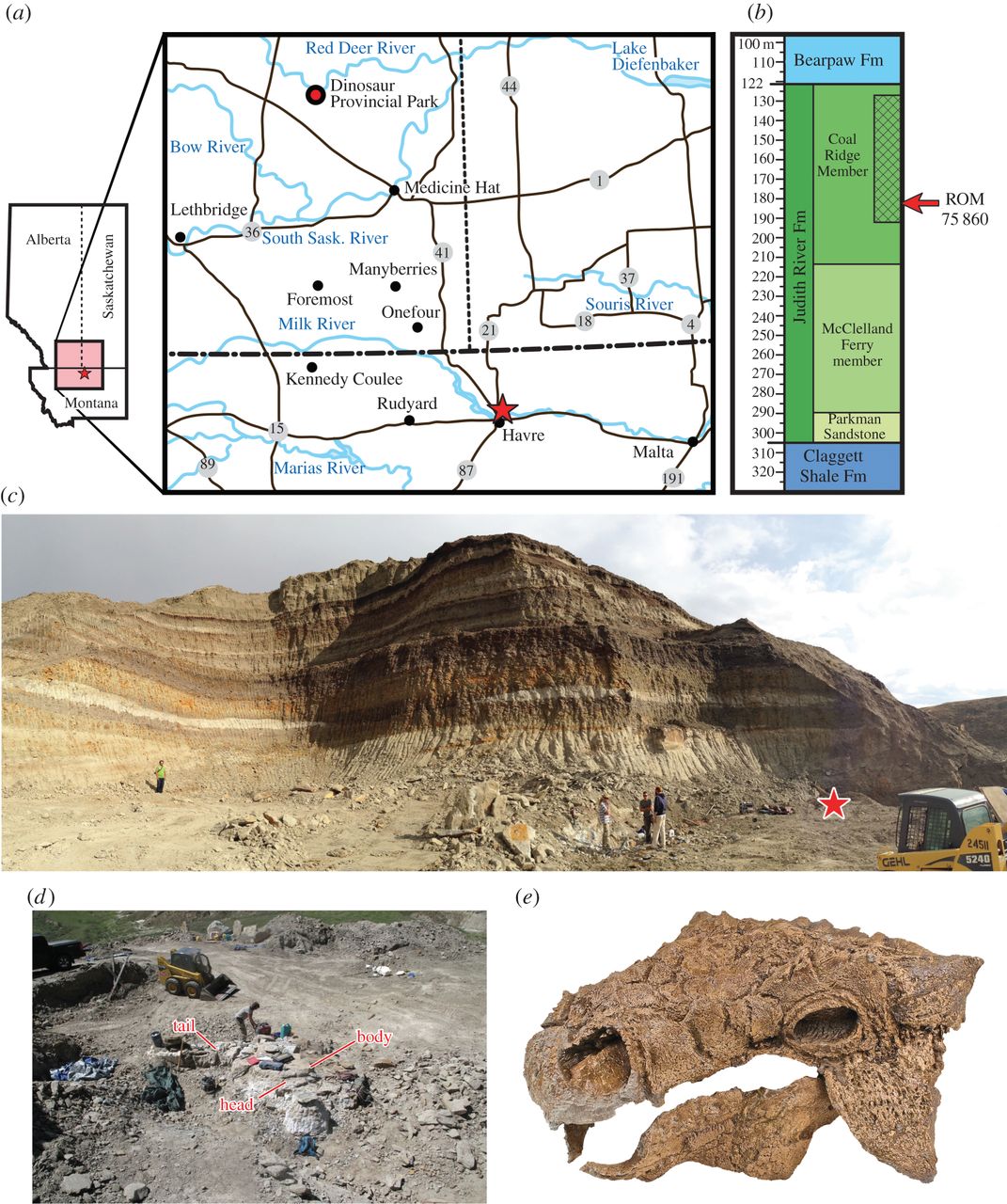
| Описание | Holotype locality for ROM 75860, Zuul crurivastator. (a) Map showing the geographical location of ROM 75860, marked with a star, near Havre, Montana. (b) Approximate stratigraphic range of the host stratum of ROM 75860 within the Coal Ridge Member of the Judith River Formation. (c) Panoramic view of the Z. crurivastator quarry, with the location of the specimen marked by a star. (d) Orientation of ROM 75860 in the quarry during excavation. (e) Well-preserved skull and jaws of ROM 75860 showing quality of preservation. |
|---|---|
| Источник | http://rsos.royalsocietypublishing.org/content/4/5/161086 |
| Время создания | 2017 |
| Автор или правообладатель | Victoria M. Arbour, David C. Evans — Лицензия: CC BY 4.0 (Creative Commons Attribution 4.0) https://creativecommons.org/licenses/by/4.0 |
| Другие версии файла | — |
Источник файла — сайт Wikimedia Commons, куда он был загружен под одной из свободных лицензий ( https://commons.wikimedia.org/wiki/File:Zuul_locality.jpg ). Авторов, работавших над этим файлом см. в истории файла: https://commons.wikimedia.org/w/index.php?title=File:Zuul_locality.jpg&action=history


В общем случае в статьях энциклопедии Руниверсалис файлы используются в соответствии со статьёй 1274 Гражданского кодекса Российской Федерации.
История файла
Нажмите на дату/время, чтобы увидеть версию файла от того времени.
| Дата/время | Миниатюра | Размеры | Участник | Примечание | |
|---|---|---|---|---|---|
| текущий | 19:53, 26 января 2024 | | 1071 × 1280 (281 КБ) | I, Robot (обсуждение | вклад) | == Описание == {{Изображение | описание = Holotype locality for ROM 75860, Zuul crurivastator. (a) Map showing the geographical location of ROM 75860, marked with a star, near Havre, Montana. (b) Approximate stratigraphic range of the host stratum of ROM 75860 within the Coal Ridge Member of the Judith River Formation. (c) Panoramic view of the Z. crurivastator quarry, with the location of the specimen marked by a star. (d) Orientation of ROM 75860 in the quarry during excavation. (e) Well-p... |
Вы не можете перезаписать этот файл.
Использование файла
Следующий файл является дубликатом этого файла (подробности):

- Файл:Zuul locality.jpg на общем хранилище
Следующая страница использует этот файл:
