


Файл:Zagros 1992.jpg
Нет версии с бо́льшим разрешением.
Zagros_1992.jpg (639 × 511 пкс, размер файла: 106 КБ, MIME-тип: image/jpeg)
Описание
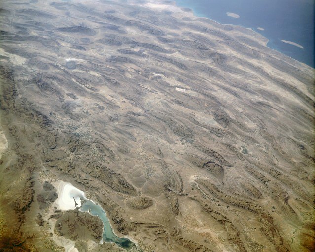
| Описание | Zagros Mountains, Iran. Photo center point: 28.0° N, 54.0° E (near Banaruyeh). NASA Space Shuttle photo STS047-151-35.JPG. One of the most beautifully folded mountain ranges in the world, the southern Zagros Mountains of western Iran can be seen in this south-southwest looking low oblique view. Pushed up by the collision of crustal plates, the Zagros Mountains were buckled into high folds, or anticlines, and depressions, or synclines. Extending from northwest to southeast is a broad zone of long parallel lines of enormous hogback ridges and deep intervening valleys (right center to upper center of the image). There are numerous salt marshes in many of the valleys, such as Lake Bakhtegan, visible in the lower left portion of the image. Iran's major oil fields lie along the western foothills, where salt domes have trapped oil. The Persian Gulf is visible in the upper right portion of the image. |
|---|---|
| Источник | NASA |
| Время создания | 1992-09-13 |
| Автор или правообладатель | NASA — Лицензия: Public domain (в общественном достоянии) |
| Другие версии файла | — |
Источник файла — сайт Wikimedia Commons, куда он был загружен под одной из свободных лицензий ( https://commons.wikimedia.org/wiki/File:Zagros_1992.jpg ). Авторов, работавших над этим файлом см. в истории файла: https://commons.wikimedia.org/w/index.php?title=File:Zagros_1992.jpg&action=history


В общем случае в статьях энциклопедии Руниверсалис файлы используются в соответствии со статьёй 1274 Гражданского кодекса Российской Федерации.
История файла
Нажмите на дату/время, чтобы увидеть версию файла от того времени.
| Дата/время | Миниатюра | Размеры | Участник | Примечание | |
|---|---|---|---|---|---|
| текущий | 15:11, 8 августа 2023 | | 639 × 511 (106 КБ) | Я, робот (обсуждение | вклад) | == Описание == {{Изображение | описание = Zagros Mountains, Iran. Photo center point: 28.0° N, 54.0° E (near Banaruyeh). NASA Space Shuttle photo STS047-151-35.JPG. One of the most beautifully folded mountain ranges in the world, the southern Zagros Mountains of western Iran can be seen in this south-southwest looking low oblique view. Pushed up by the collision of crustal plates, the Zagros Mountains were buckled into high folds, or anticlines, and depressions, or synclines. Extending from... |
Вы не можете перезаписать этот файл.
Использование файла
Следующий файл является дубликатом этого файла (подробности):

- Файл:Zagros 1992.jpg на общем хранилище
Следующие 3 страницы используют этот файл:
