
Файл:Typhoon Mawar 2005 computer simulation thumbnail.gif
Typhoon_Mawar_2005_computer_simulation_thumbnail.gif (450 × 403 пкс, размер файла: 869 КБ, MIME-тип: image/gif, закольцованный, 49 фреймов, 5,3 с)
Описание
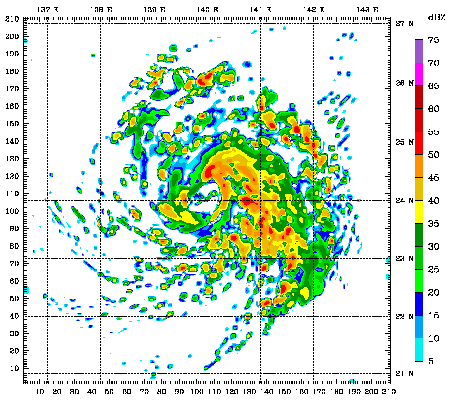
| Описание | A 48 hour simulation of Typhoon Mawar using the Weather Research and Forecasting model. At this time, Mawar was at approximately 24N 140E and moving slowly to the north. Initial conditions and boundary conditions are from the 1 degree FNL reanalysis (approximately 110 kilometers, 68 miles). The simulation runs from 22 August 2005 00:00 Zulu to 24 August 2005 00:00 Zulu. The model has 3.3 kilometre (2.1 mile) grid point spacing, and utilizes vortex following which is why the typhoon remains in the middle of the frame. Approximately the first 24 hours (frames) show the model "spinning up"— which is the amount of time needed for the model physics to reach equilibrium with the applied boundary conditions. After the initial round of convection in the first couple frames, gravity waves can be seen propagating outward from the center of convection, especially in the northwest quadrant of the storm system. The final 24 hours (frames) represent a high resolution simulation of the actual typhoon. The reds and oranges represent high rainfall rates, blues and greens light rainfall, and the white are regions of no rainfall. |
|---|---|
| Источник | |
| Время создания | 2010-07-01 15:58 |
| Автор или правообладатель |
|
| Другие версии файла | — |
Источник файла — сайт Wikimedia Commons, куда он был загружен под одной из свободных лицензий ( https://commons.wikimedia.org/wiki/File:Typhoon_Mawar_2005_computer_simulation_thumbnail.gif ). Авторов, работавших над этим файлом см. в истории файла: https://commons.wikimedia.org/w/index.php?title=File:Typhoon_Mawar_2005_computer_simulation_thumbnail.gif&action=history
В общем случае в статьях энциклопедии Руниверсалис файлы используются в соответствии со статьёй 1274 Гражданского кодекса Российской Федерации.
История файла
Нажмите на дату/время, чтобы увидеть версию файла от того времени.
| Дата/время | Миниатюра | Размеры | Участник | Примечание | |
|---|---|---|---|---|---|
| текущий | 18:29, 23 января 2024 | | 450 × 403 (869 КБ) | Я, робот (обсуждение | вклад) | == Описание == {{Изображение | описание = A 48 hour simulation of [https://en.wikipedia.org/wiki/Typhoon_Mawar Typhoon Mawar] using the [https://en.wikipedia.org/wiki/Weather_Research_and_Forecasting_model Weather Research and Forecasting model]. At this time, Mawar was at approximately 24N 140E and moving slowly to the north. Initial conditions and boundary conditions are from the 1 degree FNL reanalysis (approximately 110 kilometers, 68 miles). The simulation runs from 22 August 2005 00:00... |
Вы не можете перезаписать этот файл.
Использование файла
Следующий файл является дубликатом этого файла (подробности):
- Файл:Typhoon Mawar 2005 computer simulation thumbnail.gif на общем хранилище
Следующая страница использует этот файл: