
Файл:PIA17085-MarsCuriosityRover-TraverseMap-Sol351-20130801.jpg

Исходный файл (2640 × 2040 пкс, размер файла: 944 КБ, MIME-тип: image/jpeg)
Описание
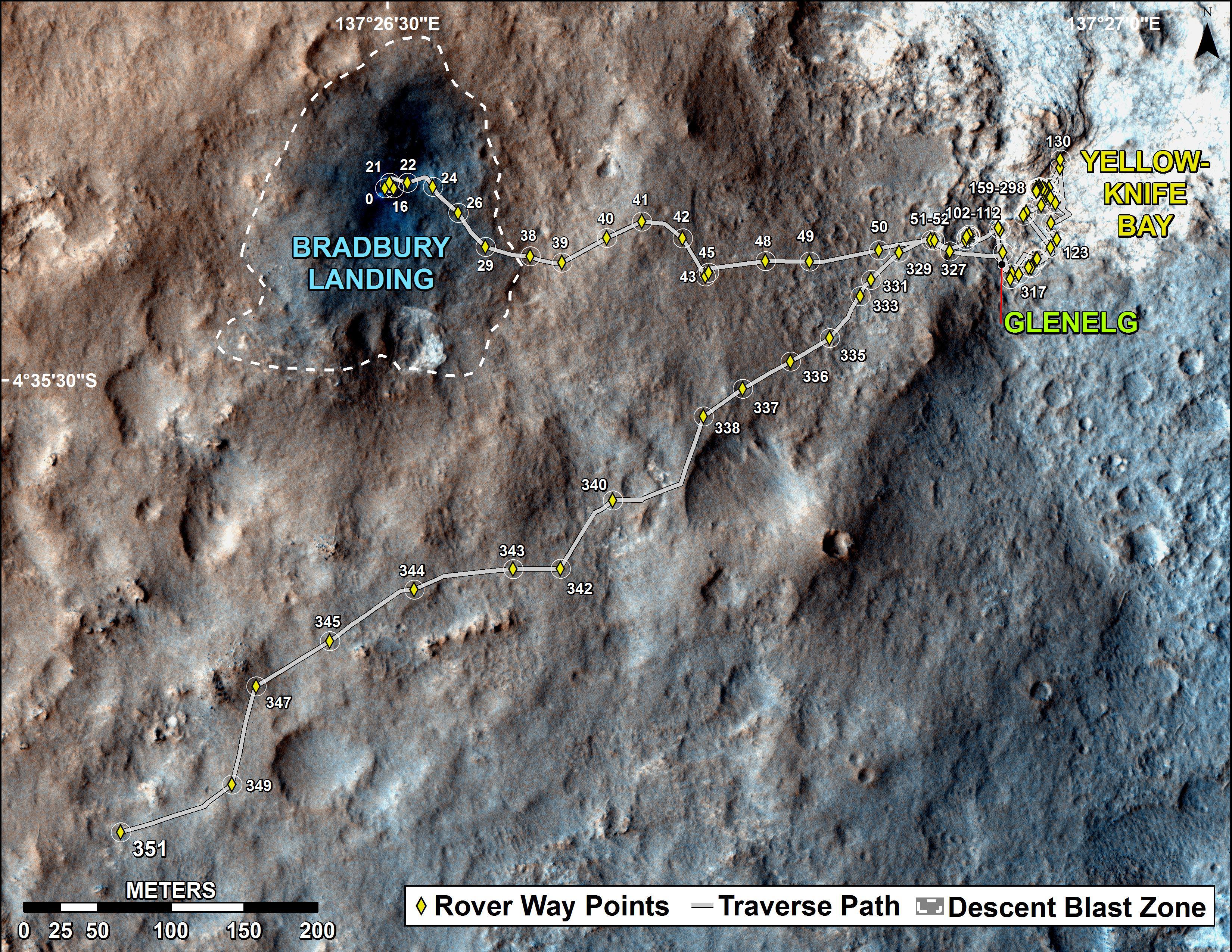
| Описание | PIA17085: Full Curiosity Traverse Passes One-Mile Mark
http://photojournal.jpl.nasa.gov/catalog/PIA17085 NOTE: UPDATED Traverse Maps Are Here => http://mars.jpl.nasa.gov/msl/mission/whereistherovernow/ NOTE: First-Year & First-Mile Traverse Map of the Curiosity rover on Mars (August 1, 2013) (3-D). NASA Description: The total distance driven by NASA's Mars rover Curiosity passed the one-mile mark a few days before the first anniversary of the rover's landing on Mars. This map traces where Curiosity drove between landing at "Bradbury Landing" on Aug. 5, 2012, PDT, (Aug. 6, 2012 (Universal Time and EDT) and the position reached during the mission's 351st Martian day, or sol, (Aug. 1, 2013). The Sol 351 leg added 279 feet (85.1 meters) and brought the odometry since landing to about 1.05 miles (1,686 meters). The mapped area is within Gale Crater and north of the mountain called Mount Sharp in the middle of the crater. After the first use of the drill, the rover's main science destination will be on the lower reaches of Mount Sharp. For broader-context images of the area, see PIA16064 and PIA16058. The base image from the map is from the High Resolution Imaging Science Experiment Camera (HiRISE) in NASA's Mars Reconnaissance Orbiter. |
|---|---|
| Источник | http://photojournal.jpl.nasa.gov/jpeg/PIA17085.jpg |
| Время создания | 2013-08-02 18:15:29 |
| Автор или правообладатель | NASA/JPL-Caltech/Univ. of Arizona — Лицензия: Public domain (в общественном достоянии) |
| Другие версии файла | — |
Источник файла — сайт Wikimedia Commons, куда он был загружен под одной из свободных лицензий ( https://commons.wikimedia.org/wiki/File:PIA17085-MarsCuriosityRover-TraverseMap-Sol351-20130801.jpg ). Авторов, работавших над этим файлом см. в истории файла: https://commons.wikimedia.org/w/index.php?title=File:PIA17085-MarsCuriosityRover-TraverseMap-Sol351-20130801.jpg&action=history
В общем случае в статьях энциклопедии Руниверсалис файлы используются в соответствии со статьёй 1274 Гражданского кодекса Российской Федерации.
История файла
Нажмите на дату/время, чтобы увидеть версию файла от того времени.
| Дата/время | Миниатюра | Размеры | Участник | Примечание | |
|---|---|---|---|---|---|
| текущий | 20:24, 15 декабря 2023 | | 2640 × 2040 (944 КБ) | I, Robot (обсуждение | вклад) | == Описание == {{Изображение | описание = PIA17085: Full Curiosity Traverse Passes One-Mile Mark <p>[http://photojournal.jpl.nasa.gov/catalog/PIA17085 http://photojournal.jpl.nasa.gov/catalog/PIA17085] </p><p>NOTE: UPDATED Traverse Maps Are Here => [http://mars.jpl.nasa.gov/msl/mission/whereistherovernow/ http://mars.jpl.nasa.gov/msl/mission/whereistherovernow/] </p><p>NOTE: First-Year & First-Mile [http://mars.jpl.nasa.gov/msl/mission/whereistherovernow/ Traverse Map] of the <i>Curi... |
Вы не можете перезаписать этот файл.
Использование файла
Следующая страница использует этот файл: