
Файл:Mars 2020 Sample Collection Map.jpg
Mars_2020_Sample_Collection_Map.jpg (800 × 450 пкс, размер файла: 254 КБ, MIME-тип: image/jpeg)
Описание
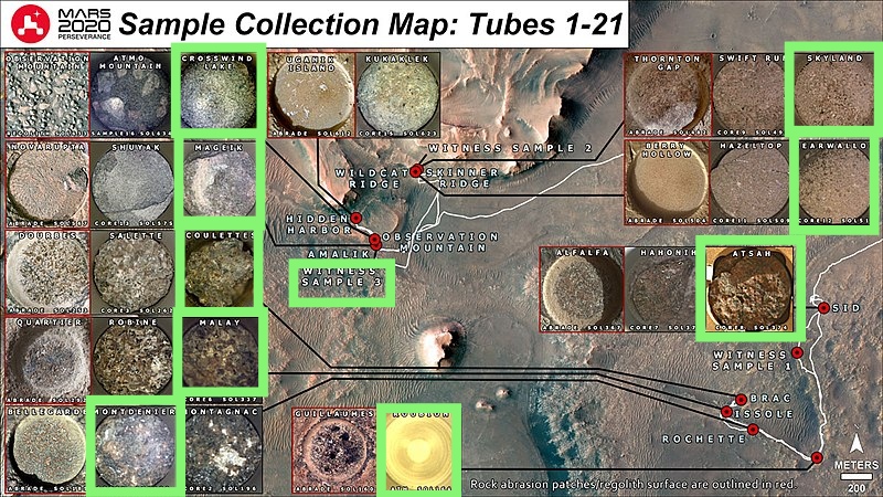
| Описание | This annotated map shows the locations where NASA’s Perseverance Mars rover collected its first 3 witness tubes and filled its 21 samples. It is a base map with geographic information of the ascent line shown on it.
The name that the Perseverance science and operations teams used to define a rock target on the Martian surface appears at the top of each inset image. Also indicated is the Martian day, or sol, of the rover’s mission and whether the image shows a target that has been abraded for proximity science or from which a core sample was taken. Before collecting a sample, Perseverance uses its drill to abrade the upper few millimeters of the rock surface close to the intended coring target. Those inset images annotated with the word “abrade” were captured by the rover’s WATSON imager. Those with “core” were taken by the rover’s CacheCam, which visually inspects a sample tube after a coring event takes place. A key objective for Perseverance’s mission on Mars is astrobiology, including the search for signs of ancient microbial life. The rover will characterize the planet’s geology and past climate, pave the way for human exploration of the Red Planet, and be the first mission to collect and cache Martian rock and regolith (broken rock and dust). Subsequent NASA missions, in cooperation with ESA (European Space Agency), would send spacecraft to Mars to collect these sealed samples from the surface and return them to Earth for in-depth analysis. The Mars 2020 Perseverance mission is part of NASA’s Moon to Mars exploration approach, which includes Artemis missions to the Moon that will help prepare for human exploration of the Red Planet. JPL, which is managed for NASA by Caltech in Pasadena, California, built and manages operations of the Perseverance rover. |
|---|---|
| Источник | |
| Время создания | 2022-09-28 |
| Автор или правообладатель | 文爻林夕/NASA/JPL-Caltech/ASU/MSSS; Lori Glaze — Лицензия: Public domain (в общественном достоянии) |
| Другие версии файла | — |
Источник файла — сайт Wikimedia Commons, куда он был загружен под одной из свободных лицензий ( https://commons.wikimedia.org/wiki/File:Mars_2020_Sample_Collection_Map.jpg ). Авторов, работавших над этим файлом см. в истории файла: https://commons.wikimedia.org/w/index.php?title=File:Mars_2020_Sample_Collection_Map.jpg&action=history
В общем случае в статьях энциклопедии Руниверсалис файлы используются в соответствии со статьёй 1274 Гражданского кодекса Российской Федерации.
История файла
Нажмите на дату/время, чтобы увидеть версию файла от того времени.
| Дата/время | Миниатюра | Размеры | Участник | Примечание | |
|---|---|---|---|---|---|
| текущий | 17:53, 15 августа 2023 | | 800 × 450 (254 КБ) | Я, робот (обсуждение | вклад) | == Описание == {{Изображение | описание = This annotated map shows the locations where NASA’s Perseverance Mars rover collected its first 3 witness tubes and filled its 21 samples. It is a base map with geographic information of the ascent line shown on it. <p>The name that the Perseverance science and operations teams used to define a rock target on the Martian surface appears at the top of each inset image. Also indicated is the Martian day, or sol, of the rover’s mission and whether the i... |
Вы не можете перезаписать этот файл.
Использование файла
Следующий файл является дубликатом этого файла (подробности):
- Файл:Mars 2020 Sample Collection Map.jpg на общем хранилище
Следующие 2 страницы используют этот файл: