
Файл:GeneralMapOfDistancesAndHistoricCapitals.jpg
Размер этого предпросмотра: 744 × 599 пкс. Другие разрешения: 2542 × 2048 пкс | 2794 × 2251 пкс.
Исходный файл (2794 × 2251 пкс, размер файла: 606 КБ, MIME-тип: image/jpeg)
Описание
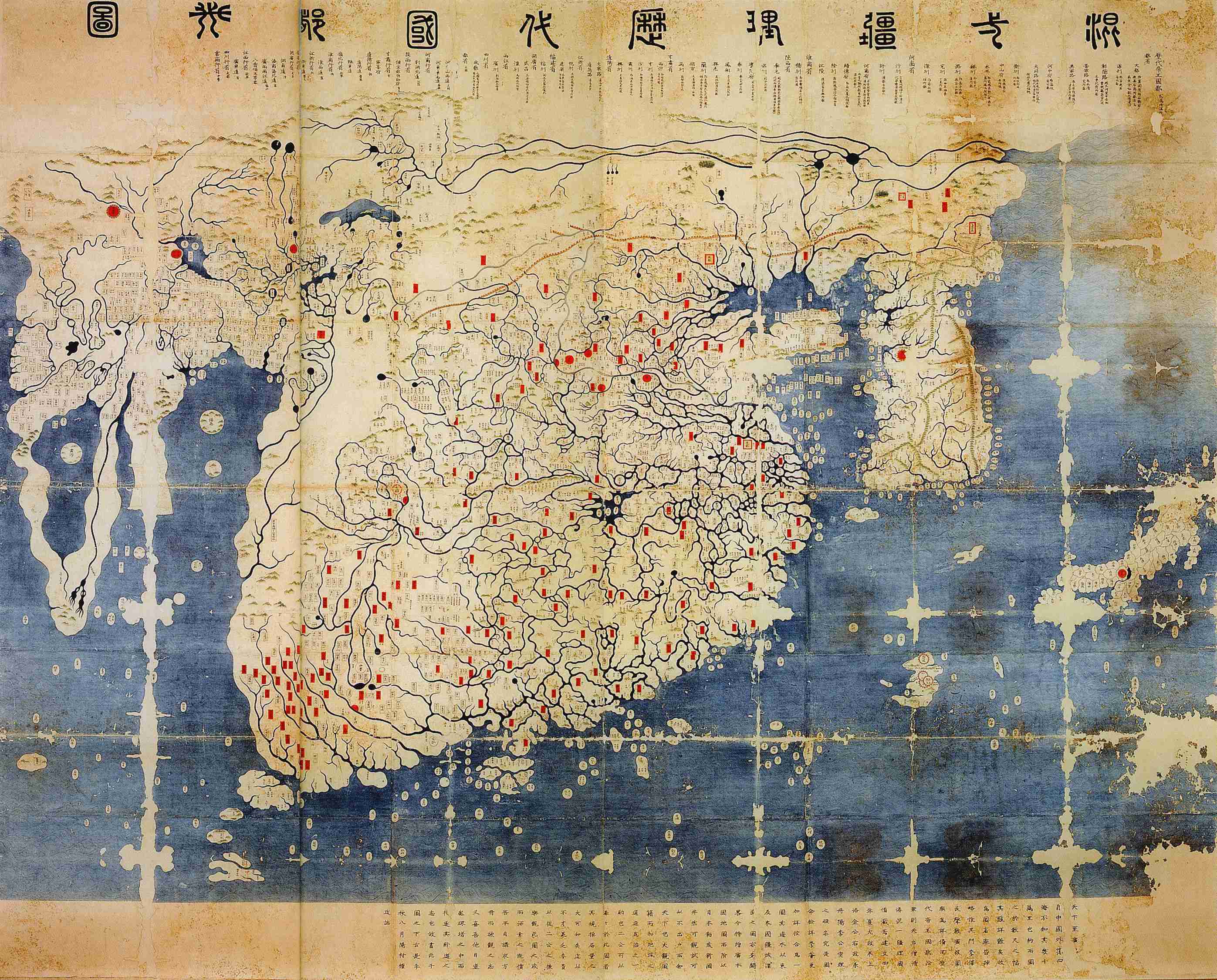
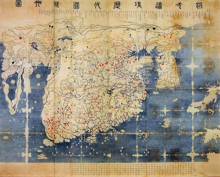
| Описание | General map of the distances and the historic capitals (chinese: Hunyi jiangli lidai guodu zhi tu; japanese: Kon'itsu kyoori rekidai kokuto no zu), Korea, roughly 1402. Ink and paint on paper. Height 220 cm, width 289 cm. Honkoo-ji Tokiwa Museum of Historical Materials, Shimabara, Nagasaki prefecture. Based on two Chinese maps from the 14th century, Shengjiao guangbei tu (Big map that shows the pronounciation of place names) and Hunyi jiangli tu (General map of the distances also showing historical capitals [of China]). Both maps were brought to Korea in 1368, and put together to one new map around 1402. The most obvious feature distinguishing this later version from the original Kangnido is the more correct size and orientation of Japan. The geographical knowledge represented in the map beyond China and Korea seems mainly a result of 14th century trade connections within the Mongol Empire. On the western edge of the map the names Marseille and Sevilla have been identified. Note the depiction of the Cape of Good Hope, the second-earliest known to date. Note: The "crack" on the left side of the image is due to the map being printed on two adjacent pages in the source, an exhibition catalogue. It is not from the original (just in case someone might wonder). |
|---|---|
| Источник | Dschingis Khan und seine Erben (exhibition catalogue), München 2005, p. 336/7 |
| Время создания | 1402 |
| Автор или правообладатель |
Kim Sahyung, Lee Moo, Lee Hui — Лицензия: Public domain (в общественном достоянии)
|
| Другие версии файла | — |
Источник файла — сайт Wikimedia Commons, куда он был загружен под одной из свободных лицензий ( https://commons.wikimedia.org/wiki/File:GeneralMapOfDistancesAndHistoricCapitals.jpg ). Авторов, работавших над этим файлом см. в истории файла: https://commons.wikimedia.org/w/index.php?title=File:GeneralMapOfDistancesAndHistoricCapitals.jpg&action=history
В общем случае в статьях энциклопедии Руниверсалис файлы используются в соответствии со статьёй 1274 Гражданского кодекса Российской Федерации.
История файла
Нажмите на дату/время, чтобы увидеть версию файла от того времени.
| Дата/время | Миниатюра | Размеры | Участник | Примечание | |
|---|---|---|---|---|---|
| текущий | 10:49, 13 октября 2023 | | 2794 × 2251 (606 КБ) | Я, робот (обсуждение | вклад) | == Описание == {{Изображение | описание = General map of the distances and the historic capitals (chinese: Hunyi jiangli lidai guodu zhi tu; japanese: Kon'itsu kyoori rekidai kokuto no zu), Korea, roughly 1402. Ink and paint on paper. Height 220 cm, width 289 cm. Honkoo-ji Tokiwa Museum of Historical Materials, Shimabara, Nagasaki prefecture. Based on two Chinese maps from the 14th century, <i>Shengjiao guangbei tu</i> (Big map that shows the pronounciation of place names) and <i>Hunyi jiang... |
Вы не можете перезаписать этот файл.
Использование файла
Следующая страница использует этот файл: