
Файл:Caspian Sea from orbit.jpg
Размер этого предпросмотра: 471 × 599 пкс. Другие разрешения: 1609 × 2048 пкс | 3080 × 3919 пкс.
Исходный файл (3080 × 3919 пкс, размер файла: 1,15 МБ, MIME-тип: image/jpeg)
Описание
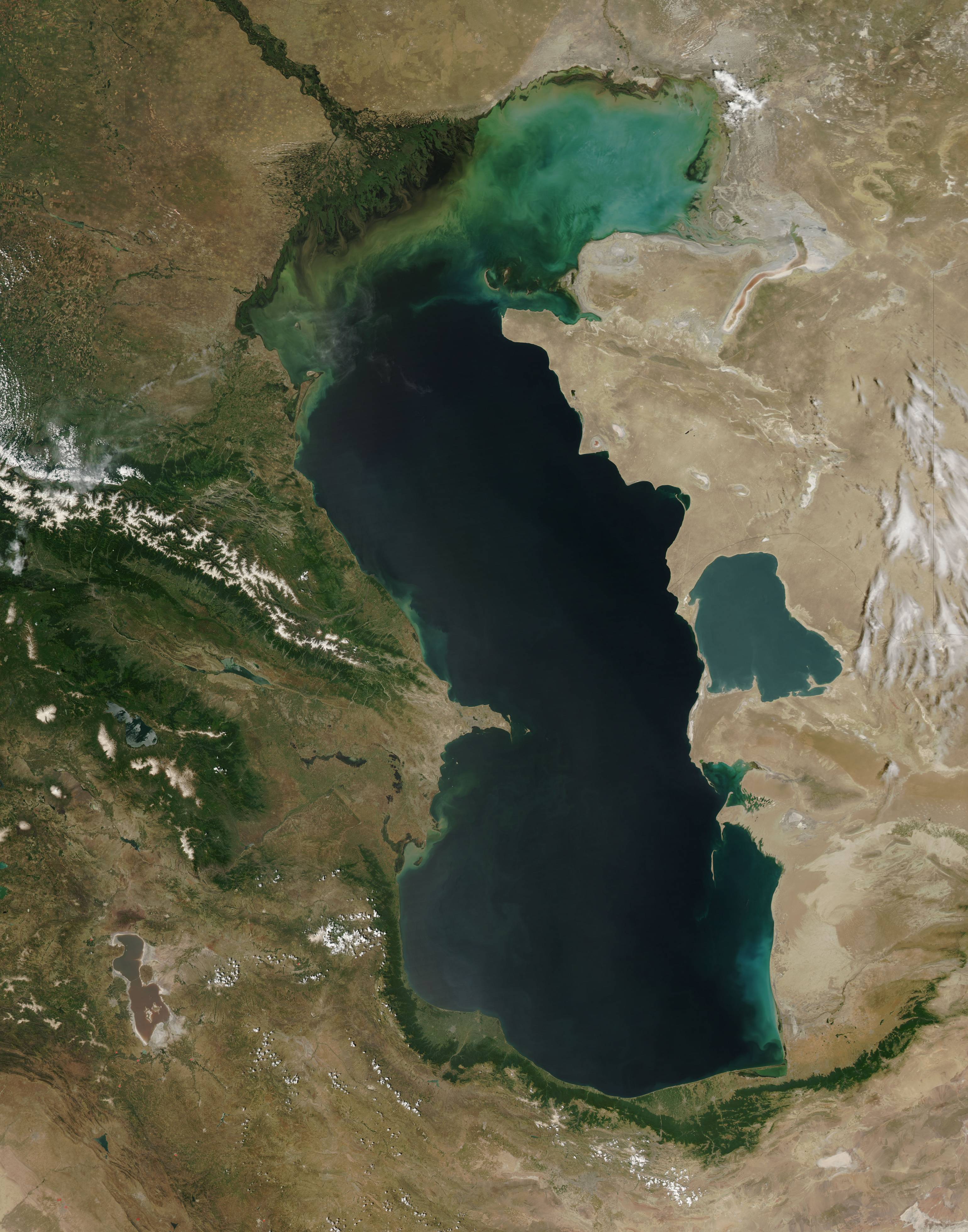
| Описание | This is a view from orbit of the Caspian Sea as imaged by the MODIS sensor on the Terra satellite. Caption: The original caption from NASA: ::"The northern part of the Caspian Sea is plagued by a process called eutrophication, in which agricultural run-off rich in fertilizers stimulates rampant growth of algae in the water. The death and decay of these algae robs the water of oxygen, with obvious negative consequences for aquatic life. This image of the Caspian Sea shows swirls of green and blue near the mouth of the Volga River (top center), which indicate the presence of algae. The bright blue color of the northeastern part of the sea may be due to a mixture of plant life and sediment, for this is where the sea is most shallow. This image is from the Moderate Resolution Imaging Spectroradiometer (MODIS) on the Terra satellite on June 11, 2003. |
|---|---|
| Источник | http://visibleearth.nasa.gov/view_rec.php?id=5514
|
| Время создания | 2003-06-11 |
| Автор или правообладатель | Jeff Schmaltz, MODIS Rapid Response Team, NASA/GSFC — Лицензия: Public domain (в общественном достоянии) |
| Другие версии файла | — |
Источник файла — сайт Wikimedia Commons, куда он был загружен под одной из свободных лицензий ( https://commons.wikimedia.org/wiki/File:Caspian_Sea_from_orbit.jpg ). Авторов, работавших над этим файлом см. в истории файла: https://commons.wikimedia.org/w/index.php?title=File:Caspian_Sea_from_orbit.jpg&action=history
В общем случае в статьях энциклопедии Руниверсалис файлы используются в соответствии со статьёй 1274 Гражданского кодекса Российской Федерации.
История файла
Нажмите на дату/время, чтобы увидеть версию файла от того времени.
| Дата/время | Миниатюра | Размеры | Участник | Примечание | |
|---|---|---|---|---|---|
| текущий | 14:36, 6 августа 2023 | | 3080 × 3919 (1,15 МБ) | I, Robot (обсуждение | вклад) | == Описание == {{Изображение | описание = This is a view from orbit of the [https://commons.wikimedia.org/wiki/Caspian_Sea Caspian Sea] as imaged by the MODIS sensor on the Terra satellite. <b>Caption:</b> The original caption from [https://commons.wikimedia.org/wiki/NASA NASA]: ::"The northern part of the Caspian Sea is plagued by a process called [https://commons.wikimedia.org/w/index.php?title=Eutrophication&action=edit&redlink=1 eutrophication], in which agricultural run-off ric... |
Вы не можете перезаписать этот файл.
Использование файла
Следующие 3 страницы используют этот файл: