
Файл:Aerial View of K-25.jpg
Исходный файл (980 × 780 пкс, размер файла: 244 КБ, MIME-тип: image/jpeg)
Описание
| Описание | Title
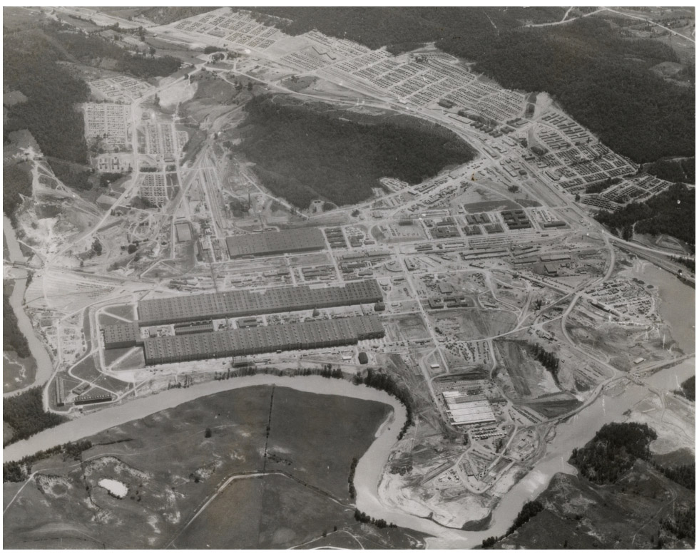
Aerial View of K-25 Subject Manhattan Project (U.S.) Description This aerial photograph depicts K-25 and the surrounding area. K-25 was one of the uranium enrichment facilities at Oak Ridge that produced uranium for the Manhattan Project. K-25 was horseshoe shaped and covered an area of 44-acres. In the upper part of the photograph can be seen "Happy Valley," which was the residential area where construction workers and plant laborers lived. Creator Records of the Atomic Energy Commission, Record Group 326 Source Formerly Classified Correspondence Files, 1942-1947 Date 1944-1946 Rights National Archives at Atlanta Format Still Image Language English Identifier ARC Identifier 1518690 |
|---|---|
| Источник | National Archives |
| Время создания | 2013-02-26 10:52:56 |
| Автор или правообладатель | Manhattan Project — Лицензия: Public domain (в общественном достоянии) |
| Другие версии файла | — |
Источник файла — сайт Wikimedia Commons, куда он был загружен под одной из свободных лицензий ( https://commons.wikimedia.org/wiki/File:Aerial_View_of_K-25.jpg ). Авторов, работавших над этим файлом см. в истории файла: https://commons.wikimedia.org/w/index.php?title=File:Aerial_View_of_K-25.jpg&action=history
В общем случае в статьях энциклопедии Руниверсалис файлы используются в соответствии со статьёй 1274 Гражданского кодекса Российской Федерации.
История файла
Нажмите на дату/время, чтобы увидеть версию файла от того времени.
| Дата/время | Миниатюра | Размеры | Участник | Примечание | |
|---|---|---|---|---|---|
| текущий | 23:23, 6 сентября 2023 | | 980 × 780 (244 КБ) | I, Robot (обсуждение | вклад) | == Описание == {{Изображение | описание = Title <p>Aerial View of K-25 Subject Manhattan Project (U.S.) Description This aerial photograph depicts K-25 and the surrounding area. K-25 was one of the uranium enrichment facilities at Oak Ridge that produced uranium for the Manhattan Project. K-25 was horseshoe shaped and covered an area of 44-acres. In the upper part of the photograph can be seen "Happy Valley," which was the residential area where construction workers and plant laborers lived.... |
Вы не можете перезаписать этот файл.
Использование файла
Следующий файл является дубликатом этого файла (подробности):
- Файл:Aerial View of K-25.jpg на общем хранилище
Следующая страница использует этот файл: